Wednesday, June 13, 2012

Coast Ride with entertaining Devils Slide Bypass

Some interesting moments on the bike over the last few weeks as I have been doing the panicked It's-almost-the-end-of-the-school-year riding that always occurs in late May and early June:

  • Detoured onto 280 for an exit due to trail construction (not as bad as it sounds).
  • Startled by a gigantic T Rex sculpture in someone's back yard on an obscure road in the Santa Cruz Mountains (too bad no camera).
  • Rode right by Wile E. Coyote's mailbox  (too bad no camera again).
  • Climbed many many hills and strange little dead end roads I hadn't previously explored.
  • Did a glorious coast ride, marred only by the nasty traffic on Highway 1 through the Devil's Slide area.


On returning home from the last mentioned ride, I naturally looked up a couple of maps and searched for alternatives -- and lo and behold:  I did it wrong.  I should have taken Old San Pedro Mountain Road, the old road alignment from before the section of 1 along Devil's Slide was built.

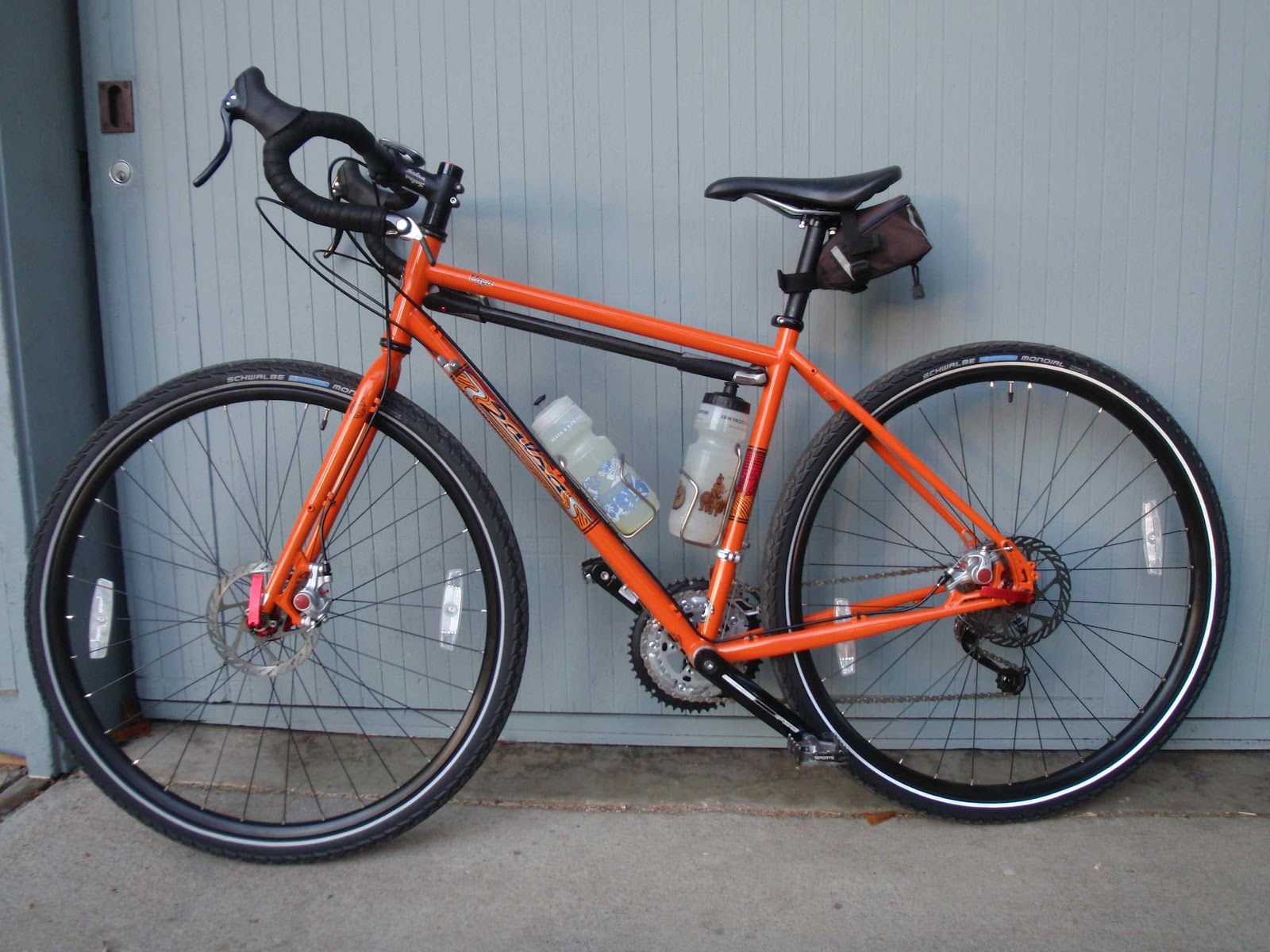
So for iteration 2 of that ride, it was time to try the dirt bypass.  I took the Vaya, not being sure what the trail surface would be like.

The start of the ride was not as straightforward as hoped -- there was a detour to the normal detour around the ongoing Crystal Springs Reservoir work.  While well-signed, this "bike and pedestrian detour" adds miles and several hundred feet of climbing.  Pity the poor unsuspecting peds.  I followed the signed detour even though I suspected there was a more efficient route through (there is, as I found upon investigating the map later at home), and even though it would likely cause me to be late getting back home.

A pleasant ride along the Sawyer Camp and San Andreas trails along the reservoirs followed, and then I followed my nose through neighborhood streets off of Sneath and found the somewhat obscure route around the jail over to Skyline College.


Wheee!  Down Sharp Park.  Weekday riding means not much traffic; I suspect this shoulderless road could be scary if there were.  It's a short, easy descent at least.  I was amused to note that it wasn't just that it felt fast, but that the GPS data shows that I actually do descend faster on this bike than on my normal road bike.  Sticky, big, confidence-inspiring tires, I guess.

Once in Pacifica, I took a couple of neighborhood streets over to the bike path and due to lack of time, sadly skipped the exploration of Mori Point that I did last time.  Got to the end of the path, cut across Highway 1 near the hardware store, and followed another bike path into a maze of streets that had encouraging "Bike Route" signs leading me up to this intersection:


Muahaha!  "Not a Through Street" to cars, but "Gateway to Fun" for the self-propelled.  This is the entrance to Old San Pedro Mountain Road -- the old road that Highway 1 along Devil's Slide eventually replaced.  Old San Pedro Mountain Road was thought to be treacherous...like Devil's Slide isn't?  At any rate, it needed to be explored.


Lovely, lovely lovely.  This road/trail has been referred to as "Planet of the Apes" road, presumably because it looks like the last remnants of lost civilization peeking through the vegetation.


My choice of bike was a good one, as it turns out.  While you could navigate a road bike through this trail if you were careful, it's more fun not having to worry too much about occasional potholes and sand.  About 75% of it is fine for bikes with skinny tires -- where the pavement is still intact, or where the surface has fully reverted to dirt. The potholed half-pavement, half-dirt parts are more challenging -- especially on the descent.  (good pictures can be found here)  The climb itself rises 900 feet, at a steady grade of about 6%.  Not bad even if one is tired :)

A far cry from the crazed traffic on Highway 1:


At one point, I caught a glimpse of the Devil's Slide bypass tunnel work below.  Supposedly, this will be finished toward the end of the year and the old section of Highway 1 will be converted into a trail.  Until it slides into the sea, that is.  I suspect I'll continue to take the dirt Old San Pedro Mountain Road through here most of the time -- it's just more fun to be that much further off the beaten track.


After rejoining 1 in Montara (this section has a shoulder and isn't bad to ride in the tailwind direction), I really wanted to stop for food, but due to the detour of the detour earlier, didn't feel like I had time to stop.  Grrr.   I zoomed past Half Moon Bay, briefly thought about adding the bonus climb up Higgins Canyon, and instead opted for Purisima Creek Road. (Mistake -- Higgins is a lot more scenic, and only adds a couple hundred feet more)  Where the two roads intersect, I hared off into the dirt roads through Purisima Creek Redwoods, first calling Chad to let him know that I was running late in case Nimue called him worried when she got home from school.

The last few times I've been through here, I just headed straight up Purisima Creek Trail, which is quite navigable (even on the tandem!), though a bit steep at the top.  This time, for variety and to avoid some freshly-laid gravel at the top, I headed off on Borden Hatch Mill Trail, which is another dirt road with a good, predictable surface.  I'm still debating which route is better -- Borden Hatch seemed hard, but I was tired going into the ride, and the steep bits seemed steeper (to ~18%; I walked a bit due to lack of lunch) but less sustained.  They also came in the middle of the hill rather than walloping you at the end.  And, the trail popped me out onto the gentle section near the top of Tunitas, which is really quite lovely.

Despite the heat and dry weather lately, there were two minor mud pits across the trail, one of which tried to eat my foot when I unclipped briefly to regain balance in the slippery mire.  The ooshy gooshy mud that came through my bike sandal felt pretty good, as it was quite warm up near the top of the ridge.

If one were fed up by dirt, or wanted a few more miles, one could go up Lobitos and Tunitas from 1 instead.

Zoom down Kings Mountain (also faster on this bike than usual).  Partway down, Nim called me, wondering where I was.  (She didn't pick up the phone when I called the house when I got back into cell phone range).  Fortunately, I was not far from where I parked the truck, so made it home in pretty short order.

With energy left to actually make dinner instead of declaring a Go-Out-for-Pizza night.  Ha.

Tomorrow is the last day of school -- so now I need to transition to more kid-friendly adventures for a few months.

Map and profile here, for those interested.  It's really not too hard a ride, unless you are doing it on already-tired legs from the day before...


Wednesday, May 30, 2012

The Crazed Singer

...after her concert a week or so ago.

Here are my sneaky unsanctioned recordings of some of her favorite pieces.

Three pieces from Emily's Day, by Brian Holmes


Vah Kooznite, a Russian folk song


and Mary Had a Little Blues, by Charles Collins.  They all whipped out shades to wear for this one.

"Mary had a little lamb.  It's fleece was black as soot.  And everywhere that Mary went, it's sooty foot it put!  Oh baaa, baaa, Mary.  Sing baaa, baaaa to your blues...."

Tuesday, May 29, 2012

Cherry Chase Band


End-of-year concerts have been happening.  Here are some highlights of Nimue's band concert for you to enjoy.

 Three Rockin' Rodents

Sakura (Japanese folksong), with harmony part arranged and played by Nimue, along with her friend Sooah on the melody


Let's Go Band.  They all tossed their colorful hats in the air at the end.


Saturday, May 26, 2012

Celestial shadows


Last Sunday, dinner was late.  Not because the day had fallen apart.  Rather, there was an annular eclipse of the sun that almost, but not quite, reached totality in our neck of the woods right when I would normally be getting dinner on the table.  Naturally we had to go outside instead of eating.


I dug out the handy-dandy piece of welder's glass that I've been carrying around since I taught an eclipse lesson to high school students while I was in college.  Chad made a five-minute pinhole camera.  Nim kept coming outside every five minutes and commenting about how much more of the solar cookie was eaten.  We all tried to take pictures through the welder's glass to see if it could be done.


The coolest part in my mind, however, was how the gaps between the leaves of the back yard trees acted as natural pinhole cameras. I've noted this before in other eclipses, but this time the projection on the side of the house in the late afternoon low-angle sun was particularly neat.  When the wind came up, the whole set of images would shimmer and dance.


While this all happened, the daylight was noticeably dimmed.  The cats tore insanely about the house.  Of course, that might be just because they too were hungry for dinner.

Saturday, May 19, 2012

Tour of California Stages 2 and 3

For variety this year, I decided to volunteer to help at the local stages of the Tour of California instead of just being a passive spectator.  Stage 2 ended in Aptos, near Santa Cruz, and Stage 3 started in San Jose -- both reasonably convenient locations to ride over to help.

Of course, that's not taking into account that my volunteer shift in Aptos started at 8:30 am.  I got an early start, leaving the house at 5:30, rode over to to the coast, checked in and helped make coffee for the other volunteers checking in, and headed over to the finish line area to set up and organize the process for the bike valet area.  I worked there until 1:00, then headed up the course in reverse, hoping to make it to the KOM (King of the Mountains, or top of the big hill in the parlance of normal people) at the top of Bear Creek road.

Given the published expected timing of the race, I wasn't sure I'd make it all the way up and over to that point before the rolling road closure happened -- there were 22 mostly uphill miles, and possibly less than 2 hours in which to ride them.  I really wanted to make it over to the KOM point, though, first because it's a good point at which to watch both the racers and the spectators, and second, I knew Chad and his friend Dave were there somewhere.  So, I pushed hard up the hill and crossed my fingers that the race would be running late.

It was highly entertaining to ride up the course backwards.  For one thing, riding through the finishing straight made it clear that the right turn right before the finish didn't allow space after the turn for a proper sprint.   It's one thing to see that on a map or on TV, but actually being on the ground really gives you a visceral sense of how critical a racer's position going into that corner was going to be. Then, as I headed up the course, I amused myself by observing the progression of people staking out their positions to watch the race.  Lots of other were riders riding down to spectate at the finish, and there were people setting up barbecues in the yards along the route and cheering any and all others going by.  Overall, a very festive atmosphere.  I was very tempted to pull over and watch next to one big table set up outside of a winery along San Jose-Soquel Road, just based on the number of bottles of wine they had put out.

Chad was waiting at the top, though, so I pushed on.  So many other riders were heading down the hill that I started to feel like a salmon swimming upstream.  At one point I caught up to another guy headed in my direction who was also trying to reach the KOM point in time, so we leapfrogged each other along Summit Road, and -- lo and behold -- made it to the top in time.  I cruised the crowd until Chad and Dave hollered at me, and then pulled over and tried to park my bike in a spot that (a) was stable and (b) wasn't in any poison oak.  Harder than it might seem, but successful in the end.


The fast climb to make it to that point was totally worth it -- since this was the last big climb of the stage, there were a ton of spectators, including many of the crazies that give hilltops at proper bike races such character.

There was chicken guy,


Oregon dude (a fixture at the big stage races in the US as far as I can tell -- you always see him in the video coverage running with the racers up the hill),


And my person favorite, the group of what looked like Santa Cruz students freezing in their star-spangled speedos.  Their girlfriends were strewing flower petals all over the road -- a nice touch.

 The riders whooshed by in several groups, exhibiting varying degrees of suffering.  The most amusing moment came when one of the stragglers squirted his water bottle across the pale goofballs pictured above.  He may have been behind, but had clearly maintained a sense of humor.

After the race went by, I rolled back home via the fastest possible route just in time to make dinner and plan my route for the next day's stage.

Not such an early morning on Wednesday, as I was set to be a course marshall somewhere on the course heading out of San Jose, so I got Nimue off to school at the normal time and rode over to check in at the Berryessa library branch.  I figured I would be given a spot along Piedmont on the way out of town, as the organizer lady had indicated that we were really only needed within the San Jose city limits, so my plan was to man my assigned intersection until the race went by, and then slowly and gently ride up and around the KOM point on Calaveras before heading home.  Tired legs from the day before, don't you know.

As I rode up to the check-in, I overheard the guy in line in front of me discussing which location he wanted with the organizer, as she had tried to give him a spot on Calaveras, and he wanted something at the bottom.  My ears perked up.  Calaveras?  Really?  Please, oh, please, oh please give me a spot on top of the hill!

And yay -- they did indeed want someone at the intersection of Calaveras and Felter, just downhill from the KOM point.  I quickly snapped it up, and then realized I would have to ride up the hill like the wind in order to get into position in time (which admittedly was an hour before the race was supposed to start).  Another fast ride up the hill for me...

I got up to the top with plenty of time to spare, of course -- Calaveras is not that hard or long a climb.  The lack of cones with which to block the side road was a little worrisome, but several cops and firemen trickled in to enforce the road closures, leaving me with little to do other than being a race ambassador.  (And spectator)  I spent a fine hour in the sunshine chatting with the curious locals about bike racing, pointing out good places for spectators and photographers, and generally answering questions, until the race zoomed by.

Notable in the picture above are Levi Leipheimer (3-time former winner of the race in the light blue and black Omega Pharma-Quickstep kit near the center of the frame), Tejay Van Garderen (black and red BMC just in front of Levi), Chris Horner (last year's winner, in black and white RadioShack-Nissan-Trek just in front of Tejay), and Tom Danielson ( blue Garmin-Barracuda kit in front of Chris).  I also saw our perennial favorite Jens Voigt -- I'd say there was more cheering for him individually than anyone else at that point.  I'm sure the cops all thought we were nuts.

After road cleared, I should have rolled directly down the hill and back home, but the day was yet young given that I got to go up the hill before the race went by, and it seemed like a good idea to continue along Calaveras by the reservoir and go home the long way.  The ride along the reservoir was indeed just lovely.  Happy happy happy.

Until I turned to go down Niles Canyon.  This is a fairly busy road, so often not much fun, but at least it is downhill so you can keep your speed up.

In theory.  It doesn't work so well on days when the headwind is howling up the canyon so furiously that the descent feels like a climb.  Argh.

After fighting my way down, I just couldn't face going across the bridge straight into the headwind, and convinced myself that it would be faster to follow my nose down Mission Boulevard and back through Fremont and Milpitas.  Thus started the comedy of errors:

There was still an ugly headwind.
It seemed that all stoplights turned red at just the wrong time.
I missed a crititcal turn (remember I hadn't planned on going this way so hadn't looked at a map) and ended up going over a couple of absolutely heinous freeway interchanges.
I had to go much further south than I remembered.  Hungry.  Didn't bring food to go this far.
After finally reaching the highway 237 bike trail and escaping the cars, there was a fence and sign half a mile down it that said "Trail Closed" with an unhelpful bike detour arrow pointed straight toward the barrier separating the trail from the freeway.  Not sure what that was supposed to mean.
Navigating out, I made several other non-optimal turns on the way home -- all in places where I followed the bike detour signs against my internal intuition.  Whoever put those signs out must either not like cyclists or have been smoking something...

Really, I could have done without the last 35 poorly-navigated trafficky headwind horror miles of that ride.

Looking at the map later, it was clear that it would have probably been shorter to have just continued down to the Dumbarton anyway.  Feh.  On the bright side, I guess, the really delightful rides stand out in all the more contrast to the icky ones.  And the day overall was quite entertaining once again.


Wednesday, May 16, 2012

Rocket Cards

One side effect of taking science lessons into classrooms is that you often get a pile of cards.  Above is a fine specimen from taking our home-built bike-pump-powered rocket launcher into a second grade class last month for a lesson on forces and motion and how to control variables in experiments.  Lucky kids.

Chad and Nimue built the rocket launcher using instructions from MAKE magazine; I improved on the rockets by making them out of craft foam covered with clear packing tape to make them more durable.  Make one, and you too can be loved by elementary school students! (plus it's just entertaining to send the rockets zinging several hundred feet into the sky using nothing but air)

Wednesday, April 25, 2012

The genetic source of tree carnage


It's my dad's fault that I enjoy tree carnage so much.  Most recently, we got to help him take down a large cedar that was growing too close to their house.

Now they have one less tree and lots of wood for fence posts.

We tried to convince Nimue to drag branches to the debris pile, but there are so many distractions for a kid in that yard.  Fun with static electricity!

More wretched excess on the Salsa Vaya

Yesterday I went on a bike ride from home looking for things like this:


on trails like this:


and ended up riding through no fewer than eight parks, 50 miles of mixed dirt and pavement, and roughly 5000 feet of climbing.

Another day, another fine ride.  Good bike.


For the curious, parks were:

Fremont Older Open Space Preserve
Montebello Open Space Preserve
Upper Stevens Creek County Park
Long Ridge Open Space Preserve
Skyline Ridge Open Space Preserve
Russian Ridge Open Space Preserve
Coal Creek Open Space Preserve
Arastradero Preserve

Could have easily picked up a couple more, given more time.  Good place to live.

Friday, April 13, 2012

Dodging rain showers

I headed out to the coast for a short hike at Wilder Ranch earlier this week, despite the threat of scattered thundershowers.  For once, I hit the gap in between showers.

Egret playing in the waves.

The seagull on the right had just gulped down a little fishie.

Lazy lazy lazy sea lions sunning themselves.

Who knew that snails swim in puddles?