
Friday, September 27, 2019
Goodbye, Small Cat
Inevitable end to kitty kidney disease this week. The kid is very sad. As are we.

TotSW: Glen Canyon Dam
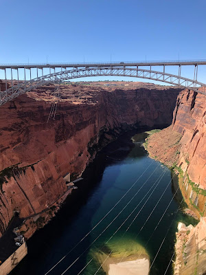
The Glen Canyon Dam is on the Colorado River right next to Page, so we took the opportunity to take a guided tour down into the dam in the morning before we headed out towards the North Rim of the Grand Canyon. It was a touristy day, but a good one.


from which you can look down at the dam.


After showing our identification, and going through a metal detector, we joined the early morning tour group. Security is pretty tight here, as one does not want to have problems with a dam that is over 700 feet tall. There is just a lot of water stored behind it!
First, we got to walk out onto the dam.


Many big turbines generate power inside the bowels of the dam. The whole tour took about 45 minutes, and was a good diversion at this point in the trip. Some history, some rocks, some engineering to marvel at...what's not to like?


The clear air led to gorgeous views.


We like how the dam seems to just spring out of the rock outcrops. All of these structures require massive feats of engineering to put in.

As we explored above, rafts full of presumably happy people floated down the river below. It looks like fun -- so maybe a notion for next time!

You may notice that the rocks in the last couple of posts have all been sedimentary. We had left the volcanic rocks behind, and were now more in fossil territory. Chad inspected the dinosaur tracks on display outside the dam visitor's center.


We were lucky to have a clear day that was not too hot -- only about 90, compared to the 105 that it was the last time we went through Page. The air was also pretty clear, which led to long views out to the layered rocks on the horizon. We started out at the visitor's center,

from which you can look down at the dam.


and out toward Lake Powell.

After showing our identification, and going through a metal detector, we joined the early morning tour group. Security is pretty tight here, as one does not want to have problems with a dam that is over 700 feet tall. There is just a lot of water stored behind it!
First, we got to walk out onto the dam.

Our guide talked about the history and structure of the dam and showed off some defunct turbines that were left after the last upgrade.


We also had plenty of time to be tourists and take pictures.


Looking down off of the dam was fun. It's tall. Note the evidence of water seeping through the sandstone on the side. This apparently was expected and taken into account, but was a bit unnerving to notice. Sandstone is porous relative to many rocks.


We then took a long elevator down into the dam to get a closer look at things below. The dam is riddled with maintenance passageways, and much cooler inside than out.


From below, one has an entirely different vantage point on the structure and surroundings.


Many big turbines generate power inside the bowels of the dam. The whole tour took about 45 minutes, and was a good diversion at this point in the trip. Some history, some rocks, some engineering to marvel at...what's not to like?

After the tour, we took a few minutes to check out the old Navajo bridge (left), which was replaced with the new bridge (right) back in the 90's.

Today, the old bridge is a pedestrian bridge, so you can cross the Colorado River and enjoy scenic river and dam views. Looking at this picture, I find it sad that they explicitly have to have a sign pointing out that it is dumb to throw rocks in the river from here.


We like how the dam seems to just spring out of the rock outcrops. All of these structures require massive feats of engineering to put in.

As we explored above, rafts full of presumably happy people floated down the river below. It looks like fun -- so maybe a notion for next time!

Thursday, September 26, 2019
TotSW: the scenic road to Page
We got a fairly late start leaving Chaco Canyon, as the day started with the short petroglyph hike in the previous post. As a result, most of rest of the day was a scenic drive across ranch and Navajo Nation land. I didn't mind; my knee needed the rest!
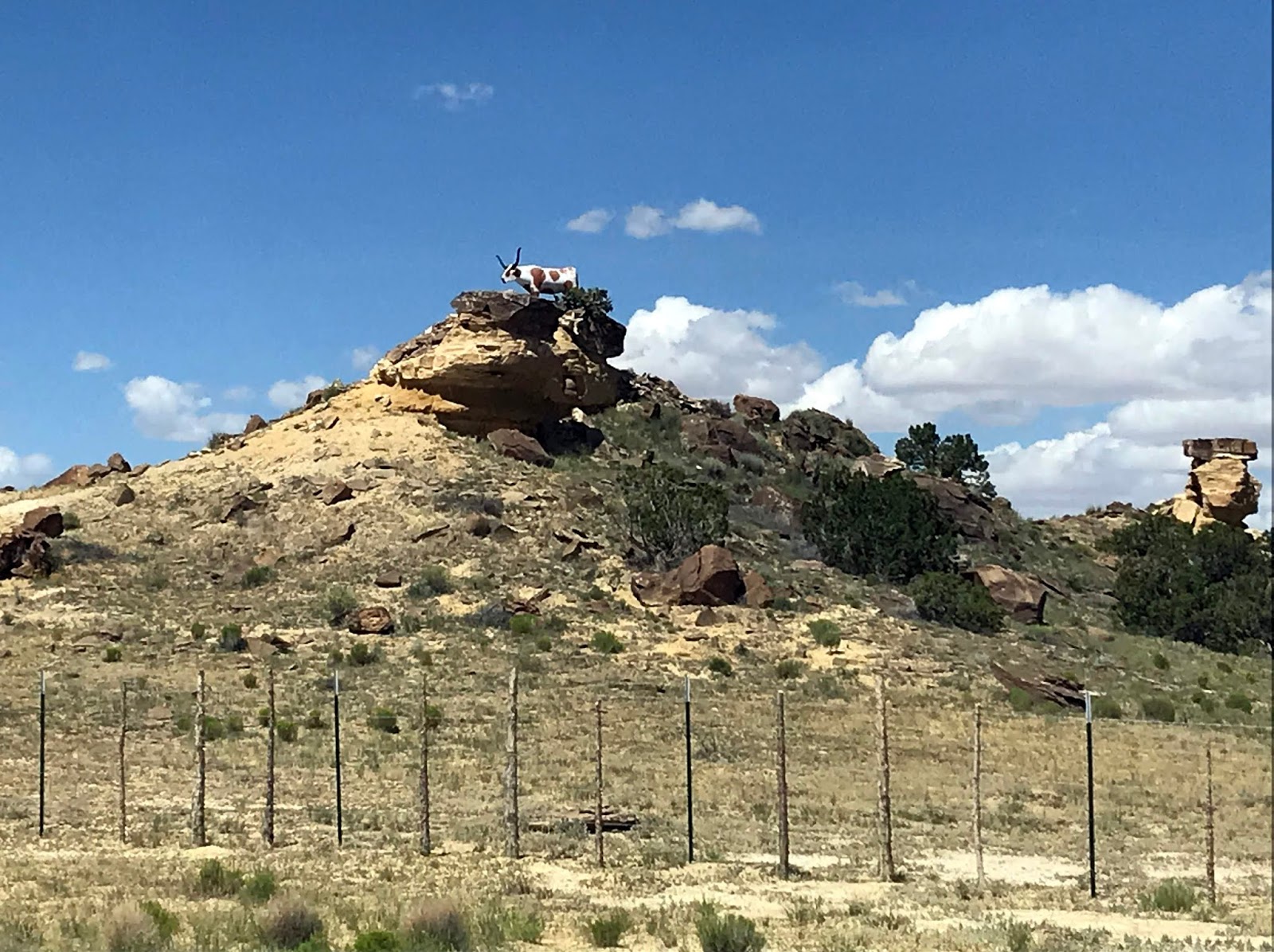
From a distance, this looked like an impressively large critter, but as we approached it became clear that it was just an amusing sculpture.


We walked a bit along the top from viewpoint to viewpoint.

One of the reasons you need a guide to go into the valley is that this national monument is actually part of Navajo land and people still live in it. In fact, this valley has been continuously inhabited for almost 5000 years. It does look to be a pleasant place to be, with the canyon walls for protection, a broad enough drainage for some agriculture, and a lazy river wandering through.


After a brief stop to look at the artifacts in the visitor's center, we continued on towards Page. It seems that every time I am on a trip going through this part of the Southwest, we end up stopping for the night in Page, AZ. All roads in this neck of the woods lead to Page. In this case, the road we took went near Monument Valley on the way and we could see interesting rock spires in the distance.

Because all roads lead to Page, there are many relatively soul-less chain hotels to choose from; we picked a nice one with a hot tub for me to soak in, got cleaned up for dinner, and walked into town to find food. The brewpub we found had fried avocado slices....mmmm. I had a big plate of fried things and a wee slider with a salad, to fortify the next day's tour of the Glen Canyon dam. Stay tuned for more.

From a distance, this looked like an impressively large critter, but as we approached it became clear that it was just an amusing sculpture.
The scenic route I plotted took us by Canyon de Chelly, which I've always wanted to see. Given the constraints of time and the fact that it requires a guide to get down into the canyon, we contented ourselves with stopping at the many scenic overlooks.


As is common in these parts, there are ancient structures built into the cliffs. There was a threat of thunderstorms blowing through, so the clouds added to the ambiance.

Close-up view of the ruins in the nook above.

We walked a bit along the top from viewpoint to viewpoint.


After a brief stop to look at the artifacts in the visitor's center, we continued on towards Page. It seems that every time I am on a trip going through this part of the Southwest, we end up stopping for the night in Page, AZ. All roads in this neck of the woods lead to Page. In this case, the road we took went near Monument Valley on the way and we could see interesting rock spires in the distance.

Because all roads lead to Page, there are many relatively soul-less chain hotels to choose from; we picked a nice one with a hot tub for me to soak in, got cleaned up for dinner, and walked into town to find food. The brewpub we found had fried avocado slices....mmmm. I had a big plate of fried things and a wee slider with a salad, to fortify the next day's tour of the Glen Canyon dam. Stay tuned for more.

Tuesday, September 24, 2019
TotSW: Chaco Culture National Historic Park
We got a little later start than usual on the way out of Santa Fe, due to having been sidetracked by conversations with the denizens of an excellent bike shop in town. As a result, it felt like time for a snack just as soon as we left the populated areas. That could have been a problem, but we miraculously found this next to a gas station: (mmmm...ice cream)


Shade was so effective at mood improvement that it was sought out at every opportunity.


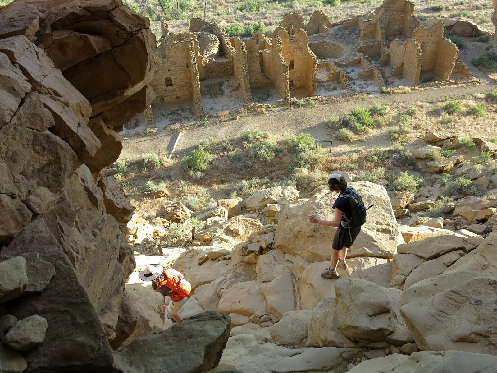
These edifices are impressive, and command views of neaby gaps through the cliffs. This area is thought to have been a crossroads for hundreds of years and trade goods from South America have been found among the artifacts here.

We knew there were some structures up on top of the adjacent mesa, so naturally we had to follow the trail. Yes, this is a trail -- see the signpost at the right of the picture?


Pueblo Bonito was built in stages over a couple of centuries between approximately 800-1100 AD, and is thought to have been at least 4 stories tall, containing 600 rooms and some 40 kivas. Clearly a site of cultural significance. The temporary green and white tents set up near the center were for a native dance event that was to be held later in the weekend.


led us to another small complex of buildings.


Different rock-stacking patterns were used during the various building periods. I particularly like the alternating big/small pattern apparent on this wall.


Chad took many, many pictures. Can you tell what the kid was thinking?


You could, however, find your way by carefully looking for cairns.

Look closely on the cliff in the center of this picture to see the ancient stairway chipped into the rock above the ledge by the white patch. The park service would frown upon anyone using that route nowadays...


More views to enjoy as the afternoon light waned and the shadows got longer.


After we looped around the top, we got to climb down the same fun way we came up.


I gave the kid a hug and then said kid hightailed it back to the car. Are we done yet? Six miles was thought to be enough.


and felt the need to follow a faint trail towards the rocks.

That kind of faint trail in these parts rewards one with petroglyphs.

I found a natural throne


This one might be my favorite petroglyph ever. Clearly a turkey!


The main goal for the day was to see the amazing pueblo ruins at Chaco Canyon. We were also hoping to find a place to camp -- I had no reservations, as there had been some work being done at the campground during the early part of the summer and they weren't guaranteeing spots. On the bright side, once we wound our way in the back way along a miles-and-miles-and-miles-long washboarded road, we found plenty of available sites in the park campground. I don't have a picture, but this is the only campground I know of where you can see pueblo ruins right from the sites (just off the right of this photo).

You can't see it in the picture, but it was crazily windy. Chad used all available line to tie things down while we watched the tent set by a noisy group of young people nearby blow away. To be fair, they might have been noisy mostly because they were trying to cope with their stuff blowing around, in good cheer at least.
With accommodation for the night settled, we headed over to the main area to take a hike.
Mid-day, it was quite warm. The kid applied shade while waiting for me to get a map.

Shade was so effective at mood improvement that it was sought out at every opportunity.


Not too far down the trail, we started to encounter signs of former multistory stone buildings.

The careful rock stacking used in the construction of these building was notably tidy and well-done. Notice the thick walls, presumably for strength and summer coolness.


As usual, I saw faces everywhere.

These edifices are impressive, and command views of neaby gaps through the cliffs. This area is thought to have been a crossroads for hundreds of years and trade goods from South America have been found among the artifacts here.

We knew there were some structures up on top of the adjacent mesa, so naturally we had to follow the trail. Yes, this is a trail -- see the signpost at the right of the picture?

Note that the small signpost just above my left leg appears to be pointing straight up the cliff,

but it really sent us up a crevice to the right. See, another signpost at the top.


The views from the top were just what you might imagine. Both the landscape and the Great Houses were laid out on a grand scale.


We noticed some interesting markings in the sandstone up top,

and were happy to spot the sign telling us what they were. Fossil shrimp burrows.

Pueblo Bonito was built in stages over a couple of centuries between approximately 800-1100 AD, and is thought to have been at least 4 stories tall, containing 600 rooms and some 40 kivas. Clearly a site of cultural significance. The temporary green and white tents set up near the center were for a native dance event that was to be held later in the weekend.


Easy walking along the top of the mesa

led us to another small complex of buildings.


Different rock-stacking patterns were used during the various building periods. I particularly like the alternating big/small pattern apparent on this wall.


Chad took many, many pictures. Can you tell what the kid was thinking?


Happy Chad.

Snacks always rejuvenate the kid. Particularly meat snacks.

Sometimes it wasn't immediately apparent where the trail went, as the top of the mesa was pretty open.

You could, however, find your way by carefully looking for cairns.

Look closely on the cliff in the center of this picture to see the ancient stairway chipped into the rock above the ledge by the white patch. The park service would frown upon anyone using that route nowadays...

As our route wound a big loop, I employed the mom super-power of holding hands to speed up the tired kid.


Chad must have thought that was cute; there are many pictures of us from this part of the afternoon.

More views to enjoy as the afternoon light waned and the shadows got longer.


After we looped around the top, we got to climb down the same fun way we came up.


I gave the kid a hug and then said kid hightailed it back to the car. Are we done yet? Six miles was thought to be enough.


However, the light was still good,

so Chad and I wandered around yet one more great house down near the parking lot.


I am impressed at how well my phone camera does, even after being pulled out of a dirty pocket and aimed straight at the sun.

Normally at this point, we would just head back to camp, eat, and go to bed. Not today, though, as I had noticed a couple of interesting evening ranger programs on the calendar when I ran through the Visitor's Center.
Chaco Canyon is designated as one of the International Dark Sky Parks, where there is almost no light pollution to diminish the stargazing experience. On summer weeknights, they open up the telescope in their little observatory, as well as setting up several more telescopes outside so that people could look at cool things like Saturn's moons, variously shaped nebulae, and the like. Given that we were there at the summer solstice, darkness arrived late.

Fortunately they had another program to keep people occupied -- a talk about the discovery of Pre-Columbian chocolate residues in cylindrical pottery jars at the site here. And the best part -- the talk was accompanied by a demonstration of grinding the beans over a heated metate, as well as tastings of the nibs, juice from the fruit pulp, and of course a couple of recipes of sipping chocolate. Yummmm. Chad and I especially liked their spicy imagining of a pre-Columbian recipe. (yes, we ran back to camp to eat a rushed dinner before the talk and chocolate consumption!) After the chocolate fun, it was fully dark, and we stayed up until quite late looking through the telescopes.
So late, in fact, that getting up at 4 am to get in line to ensure a spot for the 5:56 am summer solstice viewing of the light beam shining into the Casa Rinconada kiva didn't seem feasible. That's the sort of thing I'd like to do in a more obscure location; cramming in with the 100 people they let in after sitting in line in the wee hours of the morning just seemed wrong.
The next morning, we went over to the visitor center to buy a postcard, and of course had to run through yet another structure.


We also found a bunny friend

and felt the need to follow a faint trail towards the rocks.

That kind of faint trail in these parts rewards one with petroglyphs.

I found a natural throne

below yet more petroglyphs.

This one might be my favorite petroglyph ever. Clearly a turkey!

A most enjoyable detour, as is usual.

Subscribe to:
Posts (Atom)