Monday, July 7, 2014

hiking with Uncle Andrew

More vacation stuff -- this will continue to drip out in completely random order as the whim strikes us.

For our last full day in Australia, we went on a hike with Andrew up in the Blue Mountains near Katoomba, east of Sydney.  I was encouraged on the way to the trailhead that we drove right past the tourist stop at "Scenic World" and hared off down a dirt road to find our starting point at the Golden Staircase trailhead.  After being in the city for a few days, the need for things like dirt roads starts to take over.  Our destination was a rock formation called the Ruined Castle.

Going into it, I knew nothing other than that the name sounded promising.

Immediately past the signboard, the trail immediately plunged 600 feet down, with an average gradient of something like -35%.  Despite being tacked on the side of the cliff, the trail was mostly stair-stepped, and was quite reasonable to navigate.

And there were views

Big, open huge sky views.
After the first plummet, the trail flattened out, countering through some pretty lush vegetation.  The most interesting part was all the bird noises, including one stretch that seemed to be filled with bellbirds chirping their approximately uniform single pitch in surround sound from all directions.  Couldn't see them at all, but the aural effect was very cool.  Sadly my voice recorder chose that moment to run out of juice.

If you don't know what they sound like, this youtube video has some, though in real life it is a much more ethereal eerie sound environment with the chirps ringing from all directions.

Oddly, though this stretch was easy hiking, Nim got hungry and turned into grumpy kid.  She now sports a lovely black toenail acquired when she tripped over her own foot trying to run away from her  excessively cheerful parents.

Oooh, black toenail.  She's very proud of it.  It matches the black eye she got on the 4th of July when she threw a bottle opener up in the air in such a manner that it came down and hit her on the eyebrow.    these things just happen to 11-year-olds.  But I digress.

While she was grumpy, I found a tree that made a nice chair.
Eventually, we headed straight uphill for a couple hundred feet, followed the crest of the ridge, and came out on a vertiginous rock formation with spectacular views in all directions.  What you can't see in the pictures below is the crazy wind that came up, adding to the challenge of the rock scramble.


Our intrepid photographer
I could have played on the spires of rock here for hours, or we could have continued the hike to the next pinnacle of Mt. Solitary, but as we ate our lunch on the outcrop at the Ruined Castle and Nim cheered up, the wind continued to pick up and the sky completely clouded over.  Since there was some chance of rain in the forecast for the afternoon, we decided to head back towards the car.  Good choice, too, as the sprinkles started to fall at about the point we started back up the Golden Staircase.  Hard to believe given the nice weather at the start, but a good adventure nonetheless.

Friday, July 4, 2014

Family Portrait

For those of you who might enjoy a family portrait, here's the whole crowd of us from the recent visit to Sydney.

Wednesday, July 2, 2014

I'm Feeling Lucky

As I was making edits on some of the vacation photos in Picasa this evening, I was struck by this picture.  Sometime during every trip, Nimue gets an unexpected espresso drink.  This year, it was at a restaurant on the harbor next to the Sydney Opera house.  Picture this:  long table with 10 people seated for lunch, kids not necessarily seated near parents.  Older cousin orders a mocha without negative parental intervention.  Ma thinks "Crumbs!  Now I can't say 'No' to my own kid when she orders the same," so Nim got one too.  Later on when the drinks arrived, cousin was asked by parent "Who said you could have a coffee?...." 'Doh!  Score one for the kids.

Tuesday, July 1, 2014

Return from Backwards Land

So it's been a day and a half since we got back from the other side of the equator and date line (New Zealand and Australia), and we're still adjusting from the return from backwards land.

There's the obvious time zone difference.  Poor Chad found himself unable to sleep at 8:30am Sydney time last night.  Aside from the giant dark circles under her eyes, bouncy Nim appears to be unaffected. I'm just hungry at all the wrong times, and suffering from caffeine withdrawal (I drink decaf at home, but vacation rules are different).  I clearly need our typical New Zealand lunch of a meat pie and a flat white about now:

Also for Chad, there is the readjustment to driving on the right side of the road rather than the left.  Much concentration was put into driving on the correct side of the road, especially around the many roundabouts.  As I've noticed on other trips, the hardest part of driving on the other side of the road (at least in cheap rental cars) is that the windshield wiper and turn signal levers are reversed, leading to much spurious windshield wiping at inopportune moments.

I finally got adjusted to "other side of the road" effect as a pedestrian just before we left, and am now confusing people on sidewalks around here.  One wouldn't think this is hard, but it is.

Weather differences are also apparent.  New Zealand was full of rainbows; here in California, the grass has turned brown, it hasn't rained in what seems like forever, and the daytime highs are around 90 degrees.
But the weirdest thing for me at the moment is the abrupt shift in light levels from winter to summer.  We were used to it getting dark around 5pm (often before the end of the day's adventures).

Late afternoon view from Flagstaff Hill, near Russell, a small town known as the "Hellhole of the South Pacific" during colonial times.  Awfully nice now.

Waiting for the 5:00 ferry back from Russell.

View of Manly, Australia, from Dobroyd Head at approximately 5:00 pm.

Crazed kids after a full afternoon of walking. Pictured are Lexi, Aiden, and Nimue + Austin (before getting in trouble for sitting on the convertible).  I think Addison was still enjoying the walk with the rest of the adults while I took these, so I missed him.

Right now at home, at about 5pm, it's bright and sunny and over 80 degrees.  It won't get to the dimness level of the above pictures for another 4 or 5 hours.  Most confusing to the jet-lagged...


Wednesday, June 4, 2014

Cactus flower

Nim looked out the window yesterday morning and said "Mom -- there's a gigantic flower on the cactus!"  Indeed.


In other yard news, our apricots are coming ripe almost a month earlier than usual.  The squirrels appear not to be ready yet, and haven't been molesting them, so we may actually get a few.

The tail end of the big beginning-of-summer burst of artichokes.  You can see more apricots on the peach tree, as there is one weird little grafted branch.  Mmmmm....artichokes.  Mmmm...apricots.  Mmmm...foods that begin with "a".


Friday, May 30, 2014

Organized cacophony

SMS band concert last night.  This one is for you grandparents.

Spot the little Nim head among the music stands if you can:


Mini-backpacking trip in Portola Redwoods

We decided to go backpacking over Memorial Day weekend, but not until the last minute, so local options were somewhat limited -- nothing available for Saturday night, but one potentially lovely spot at the Slate Creek Trail camp in Portola Redwoods for Sunday night.   We're still working the kiddo up to this, so a one-night short trip wasn't necessarily a bad thing (plus it meant we could all go to the climbing gym on Saturday).  I'll let the pictures do the talking:

Before we started.  The kiddo got my pack since it could be adjusted to fit her, and my good heavyweight hiking boots.  They're narrower than I like anyway. (I had one of Chad's packs and a softer pair of boots.)

For the record: 15 lb for kiddo, 25 lb for me, and 30 lb for Chad.

From behind Nim looked like a backpack with legs.

The trail snaked gently up through the redwoods for about 3 miles, going up maybe six to eight hundred feet.  Nim was pretty cheery, except when hungry.  We still forget just how often she has to eat.

Our camp site was nestled in between the trees, in dappled sunshine.  


It was a good place for eating,

reading,

and napping.  Poor Chad had a nasty cold.

We saw a few critters, including cyanide-exuding yellow-spotted millipedes

banana slugs (including slug tracks on the outside of our tent in the morning),

and a rubber snake that Chad found in the campsite.

We saw no evidence of the ravenous raccoon the ranger warned us about, but we did hang the food overnight nonetheless.  Better safe than sorry.

There were a few wildflowers out, including a couple I don't normally see.
Redwood sorrel

Tolmie Star-Tulip

Also one of the historic mill sites.  Page apparently operated a couple of shingle mills in these parts, selectively cutting the trees with straight enough grain for shingles.  This one, apparently, was too twisty.

There are definitely some enormous trees about.  We took a detour on the way out to see the "Old Tree", which the small one deemed very large.

 Happy holiday weekend :)


Friday, May 23, 2014

Top of Umunhum

I've stared at the high point on the ridge to the west of us -- Mt. Umunhum -- both on maps and in person for years. Not only is it the local high point, promising views of both the Bay Area and Monterey, but it also has a distinctive five-story concrete cube standing on its summit. The building is both a relic of the cold war era (radar detection of incoming hostile aircraft) and a local landmark that's been a part of the ridge skyline for decades. Unfortunately, the summit has been inaccessible to the public for decades as well.

This is changing. Recently, the MROSD (the local open space district who owns the land) has been pushing forward a project to open it up. Demolition of the old air force station buildings has been completed, and they are actively working on building a new trail. However, at last check, it looked like the earliest the general public can get up there is still a few years off, in 2017.

Grrr. I really really really want to ride my bike up there. One can ride up neighboring Mt. El Sombroso and look toward Umunhum, and one can ride up Mt. Umunhum road to a similar elevation (about 3000 ft), but those last 400 ft of elevation just aren't allowed. Frustrating.
view of Umunhum from El Sombroso earlier this month

However, sometimes you get lucky.  In this case, I managed to score a ride with a ranger up to the summit to look around.  Not only did I get to enjoy the view, but the ranger was full of interesting stories about the history of the area.  Yippee!

As we drove up, we went through several gates

past security cameras


and up to the top.  The old radar tower is the last building standing while they decide what to do with it, as there is a debate between those who want to restore the site completely to its natural state, and those (including me) who see it as both a landmark and an interesting historic site.

From below, the old radar edifice looks like a cube; I was surprised to see that it is actually quite rectangular.

Despite the fog, the views all around were pretty amazing.  One really feels on top of the world.  What made it even more entertaining is the fact that I've poked around so much of the area by bike, and seeing familiar places from this different vantage point was pretty cool.

View down towards San Jose with Mt. Hamilton on the horizon


View down onto Mt. El Sombroso.  Those dirt roads you see don't look so steep, but trust me, they are!


View looking down the ridge that Soda Springs Road comes up.  This road would connect in if it weren't for some private property.

View off towards Monterey.  You can just make out the ridge that curves around Monterey Bay over the edge of the fog.  This area is apparently where the old commissary, bowling alley, and other service buildings were.  Not a bad place to be stationed, I would think!


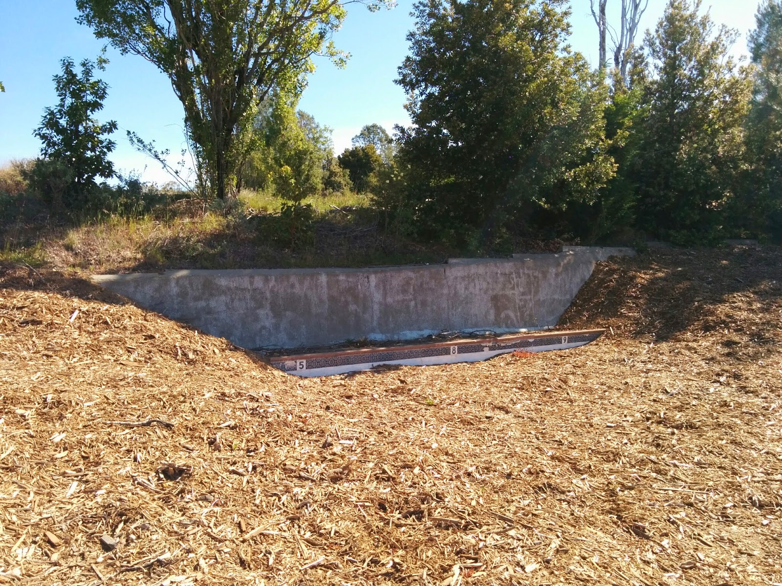
A piece of the old swimming pool.  This was the only remnant left of all the buildings that used to be here, aside from the cube itself.  I do hope that there is eventually some interpretive material with the history of the site put up here, for the benefit of those not lucky enough to explore with a knowledgeable ranger.
In case you are wondering, all the wood chips on the ground are remnants of the old buildings that they shredded and scattered to decompose.  You can't really tell from the photos, but little plants and wildflowers are already starting to poke through the chips even just a few months after demolition, so I suspect it won't take long to start looking like a more natural surface.


Damage to the tower from the 1989 Loma Prieta earthquake.  Given solidity of the building, it must have shaken pretty hard up here.  Of course, it's also quite close to where the epicenter was.

After exploring the top of the mountain, I got to walk the portion of the new trail that is currently under construction since the ranger wanted to see how it was progressing.

It's just a lovely trail so far, well-graded with good sight lines, gently switchbacking up the mountain under the edge of the tree canopy.  I would not have thought that one could route a trail up this peak that was mostly shaded, but they seem to be managing it!  And the grade is really quite reasonable, especially given the ruggedness of the surrounding terrain.  It's clearly a lot of work to put in, so I can see why they think it may be a while before it is all ready for use.

Another nice feature of the trail is that there are many and varied views of the summit as you ascend.  I can't until they finish the whole thing.  It's supposed to be a multi-use trail, and the nice routing they are choosing is not so evil that Nim couldn't ride it too :)

Wait, wait, wait.  Once they open this first trail, there will be more wait, wait waiting for connections to be made to locations on the other side so one can make loops-- but at least it appears that things are moving in the right direction!