Monday, December 14, 2020

Anniversary Trip: Wildrose Charcoal Kilns

With the likelihood of storms having passed overnight, we headed from Panamint Springs over the pass into Death Valley National Park.  Roads were clear, even though there had obviously been snowfall overnight down to about 4500 feet.  The sunny skies and possibility of a hike in the snow drew us upward, so we turned down a side road before dropping into the main valley.  Plus, there was an intriguing label of "charcoal kilns" on my map, which seemed like a good destination for the day.

The road out to the kilns headed up over another small pass, which was quite scenic in the crisp late fall air,  led past a high-elevation campground that we figured we would end up at later in the day since it was convenient and free, and eventually turned to dirt for the last few miles.  Thankfully, it was good dirt with none of the washboard horror of the previous day.

The open part of the road ended right at the row of 25' tall charcoal kilns.  These were built starting in 1877 to make charcoal to be used in the refining of ore from the mines along the edges of the Panamint Valley, including the one that we were at in Revenue Canyon the previous day.  Apparently 25 miles down one mountain, across a valley, and up another was the closest source of enough wood.  The kilns are still in remarkably good shape, likely aided by the fact that they were only in use for a couple of years.  They were built in 1877, with the last recorded use in 1879.

The view of the row of structures with a dusting of snow on the shady side looks remarkably like the photo in the guidebook that led us here.  The author must have visited in the winter also.


Naturally, we had to poke around inside them, to observe the layer of soot covering the walls and hoot at the echos inside.  A shape designed to reflect heat back at the fire reflects sound just as well!

We admired the view of the high Sierras to the west, with their fresh coating of snow.  

Poking around the kilns on its own wasn't enough recreation for the day.  Fortunately, there was a trailhead at the edge of the parking lot, and while we didn't want to climb all the way to the top of Wildrose Peak on our legs still tired from yesterday's long hike, there did look to be a saddle about halfway up from which one could peer into Death Valley proper.  Plus it would get us up into more snow!

As we hiked, we noted the lack of large trees in the area.  None of the trees close to the kilns are all that old, as the old trees were used to make charcoal back around 1878.  Everything left is younger than that.

Cactus in the snow.  I used to see this now and again in AZ, but still find it funny.

After climbing a couple of miles on the steep trail through occasionally slippery snow, we could peer through the trees down at the valley below.  At this point, we were at about 8000 feet, so the bottom of the valley, which is below sea level, looked to be quite a long way down.  A photograph doesn't do the scale of the terrain justice.

Happy Chad post snack.

After hiking and skidding our way back down the trail, we again enjoyed the views as we drove back down to the campground we saw earlier.

A fine, but cold-in-November campground.  The high peak is Telescope Peak, which at something like 11,000 feet is the highest point in the park.

As you might imagine, it got chilly after the sun went down.  At this time of year, that is at 4:30!  We ate dinner early and crawled into our cozy pod to read and sleep, and discovered the next morning that it must have been below freezing for most of the night -- the water in our big water jug we had left out was supercooled to the point that it instantly turned to slush when Chad picked it up.  

Thank goodness for all the insulation that Chad put in the van... and for the down comforter...  and for the thick quilt made out of old ski jacket scraps that my mom made some years back... and for warm fleecy pants...  (we haven't put in a heater for nighttime use yet).  


Sunday, December 13, 2020

Anniversary Trip: Revenue Canyon

After what was becoming our routine breakfast of yogurt with fruit and granola accompanied by coffee, we looked at the still-unsettled weather and decided to find a canyon with mines to explore rather than climbing a peak.  Fortunately for us, the Panamint Valley where we were is so full of canyons with old mines that there were almost too many to pick from -- especially since I had picked up a good guidebook full of interesting off-the-beaten-path spots.  We could easily have spent the whole trip goofing off in this little region without even making it over to Death Valley.

But that wasn't the plan, so I pointed my finger at the book and landed on a page that told us to go park behind a limestone quarry here:

and head up the hills.  As we started walking up what used to be a mining road, we noticed that it had a curious track worn into part of it.  If you look closely, you can see small burro footprints.  Apparently, there are enough wild burros out here that they make their own burro-beaten paths.

We kept following the burro trail into the hills, and enjoyed the visual appeal of the varied rock formations.

and eventually started running into remnant structures from the gold and silver mining days of the 1880's.

Chad provided us with most of the day's good pictures.

We found walls and foundations of buildings

old water tanks,

and plenty of views.  Somewhere in here, we heard burros braying in a side ravine, but aside from some moment that Chad caught out of the corner of his eye, we didn't actually spot any of them.  I suspect the burros were hiding behind a rock, patiently waiting for us to go away so they could trot up and down their burro trails looking for food and water, but it was easy to imagine them sneaking quietly behind us, diving away only when we turned around to look.

At one point we hit a junction where there were several fallen wooden structures and I had to consult my map to figure out where some mine shafts with particularly colorful minerals were supposed to be.  That way!

"That way" proved to rise a bit more steeply.

A wee barrel cactus braved the rocks.

In just a few minutes, I found the expected hole in the ground.  This is an obscure enough location that the mine entrance was not barricaded off.  What is hard to tell from this picture is that the shaft starts right at the contact between two very different rock types, and there is quite a bit of color in the mineralization at the contact.

I poked my head in far enough to admire the rocks.  Chad went a little further, but not out of sight of daylight.  Though the tunnel seemed solid, one never knows when that might change, and one also never knows what remnant malodorous mine fumes may still be present, so we didn't go too far, tempting though it was.


With the day's nominal goal found, we followed the burro tracks back down the hill.  The storm still hadn't fully blown its way through,

leading to jolly changeable sunlight pools on the landscape.

At this point, I thought we might wild camp near another canyon on the east side of the valley, but it turned out the dirt road going there was covered in dreadful washboard.  One could rattle one's teeth out by going slowly and taking forever (not fun), or one could try to go fast enough to skim over the top of the bumps (didn't really smooth it out and led to some disconcerting loss of lateral traction).  Chad looked really quite pained until I pointed out that if we turned around and drove up the paved road for about half an hour, we would hit the campground at Panamint Springs, where they fortunately had a lovely site on the edge of the tent camping area for us for $10.  And we got there just before it started to rain!


Saturday, December 12, 2020

Anniversary Trip: Trona Pinnacles

When we left Red Rock Canyon, I was nominally aiming for an obscure mine and peak at the edge of Death Valley, but it quickly became clear that the weather was still a bit unstable.  Snow was forecast down to about 5000 feet, and the same "we're still getting used to the vehicle and don't want to deal with snow" thinking led us to change plans.  So, back to the trusty atlas!

It didn't take long to find the Trona Pinnacles National Natural Landmark.  Hmmm....I've never heard of that before.  A little bit of research showed that it is an area of ancient tufa formations -- pinnacles sort of like the tufa in Mono Lake, but these formed in the bed of ancient Searles Lake, which has has long since dried up.  Sounds cool.  It's on BLM land, with allows dispersed camping.  Let's go!  (Never mind that it's only an hour or so down the road; we were out to have fun and not make distance.)

The road leading into it was dirt, and a little washboarded, but not too bad.  It paralleled the old railroad tracks, and the terrain was scenic under the dramatic sky full of weather rolling through.


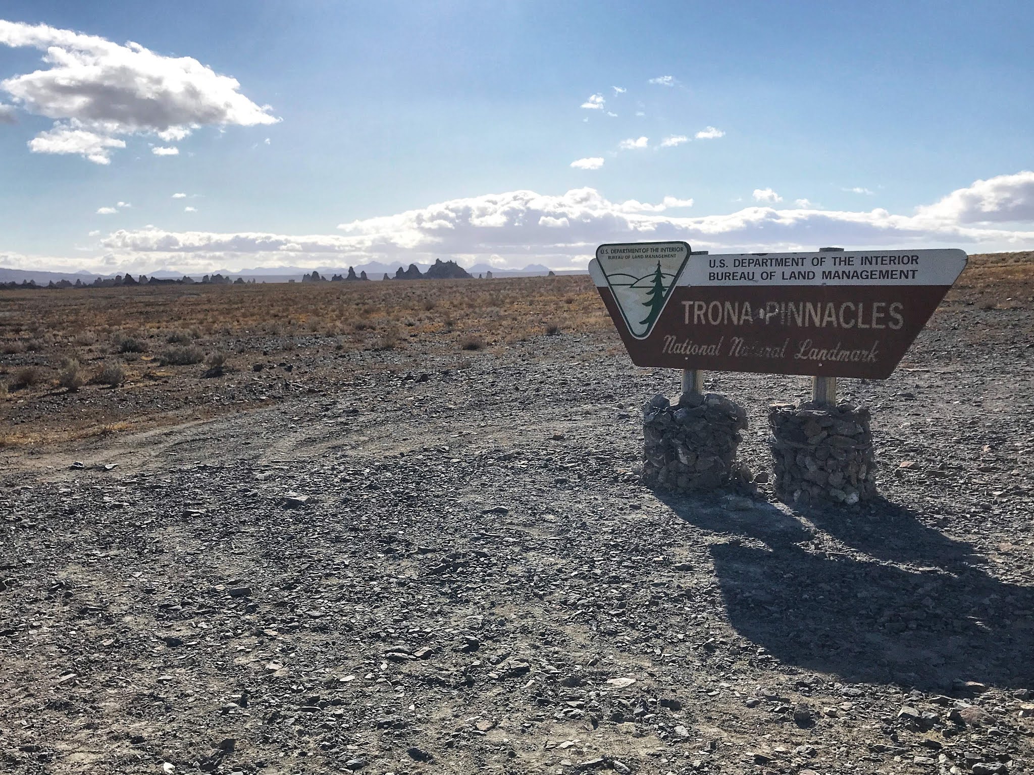
After about 5 miles of braided dirt roads, we got to the official signboard.  You can see the tufa pinnacles in the distance.  These towers of rock were formed by calcium carbonate precipitating out of an ancient lake as calcium rich spring water rose into the alkaline lake from underground.  The lake then dried up, leaving alien-seeming towers crumbling in the middle of the valley. Apparently, movies are filmed here occasionally, as one might imagine this to be an alien landscape.

As we got closer to the pinnacles, it became clear that we would not have them to ourselves, despite it seeming like the middle of nowhere.  You see, this patch of land is also designated as an off-road vehicle area, so there were people out with their jeeps, trucks, and motorcycles, zipping around the rocks.  One could be annoyed by this, but the area was big enough that everyone was spread out and we decided to look at others' recreation as our evening's free entertainment.

We found ourselves a likely looking flat spot to park the van for the night

set out for a walk,

and then found a better spot closer in to the pinnacles.


The views on our walk of exploration were fun, because the sky was ever-changing.  One could see rain in the distance, and it did sprinkle on us a little, but by and large it was pretty nice.


Windy!


The evening's entertainment as we cooked dinner was watching people drive their 4WD rigs around the not-so-difficult roads across the way.  We were amused at one point by the aural contrast between the people we couldn't see off to the north, who were engaging in redneck target shooting, and the clean-cut person in the ravine over to the south who was clearly shooting a video for social media extolling the virtues of his extra shiny SUV.  All types can enjoy BLM land.

The evening light was good.


We enjoyed the fact that our van cozy pod shielded us from the cold wind.  Chad set up one table just outside the door on which to cook, and another tiny table in the van on which to eat.  It also turns out that the refrigerator makes an excellent bench once you put a fluffy bath mat on the top of it for cushioning! 


Friday, December 11, 2020

Friday Festive Fire

 I didn’t quite get the next trip post finished today, because we enjoyed a wee fire in the courtyard after dinner instead. This is our attempt at pandemic holiday festivities.


Thursday, December 10, 2020

Anniversary Trip: Red Rock Canyon State Park

We were fortunate this year that the stars aligned to allow us to get the van, fix a few things, and then have a couple of weeks to go poking around desert California to celebrate our anniversary before we got locked down again due to the covid-19 case numbers exploding.  The kiddo stayed home and had to self-feed -- which is entirely reasonable for  an 18-year-old in college.  Ha.  Parents got to goof off in an unplanned, figure-it-out-as-you-go sort of way.  We've been a bit stir-crazy all in the house all of the time, so it was good to get outside.

The general plan was to head to Death Valley and see where that took us, hiking and mountain biking along the way.  Originally, we had thought to drive through Yosemite and do some hiking there, and then head down 395, but as the trip grew closer, it became clear that the first big storm of the season was going to hit the day we left, bringing snow to the Sierras.  They closed Tioga Pass preemptively, so that route wasn't going to work.  A closer examination of the forecast indicated that it would be cold enough to snow even over Tehachapi that night, and while that wouldn't be enough to close it, we didn't want to be dealing with chains and snow early in the trip before getting used to the new-to-us vehicle.  So, we just got up early and drove fast to outrun the storm.  No random stops for recreation on that day!

After getting over the pass, I cast about for a place to stay.  Since we hadn't planned on coming this direction at all, scanning the road atlas for campgrounds seemed to be the thing to do.  I settled on Red Rock Canyon State Park, as it was vaguely in the right direction, we could get there before dark (barely), and their website indicated that they were open for first-come, first served camping.  I figured they wouldn't be full, even though it was Friday night, because it was November and a stong cold front was coming in.

We got there around 4 pm, half an hour before the sun went down.  Sunset is *early* this time of year.  This campground turned out to be really cool -- most of the the sites are tucked up agains a long eroded sandstone cliff -- and they did have spaces left, so we grabbed one.

I took a walk down to pay for the campsite, and enjoyed the views in the low-angle late afternoon light.  At $25, this was the expensive camping night of the trip -- later nights were under $10, and sometimes free.  I'm not complaining, though, as it was a neat campground and I support the state parks.


Given the good light, Chad assumed his photographer position

with predictably good results.


Fairly soon, the light disappeared, so we set up our table and cooked dinner.  As we finished up, our evening's entertainment was watching a group of young artsy LA types in improbable shoes show up at the day use parking area just past sunset and start hiking up the ridge.  When they got to the top, they lit a giant LED light bar and proceeded to set up a photo shoot on the top of the cliffs.  We watched the backlit model and photographer while they worked, and the chuckled as they then used the light bar as an enormous flashlight to get down the now pitch dark trail.  We could hear them laughing too.

The next morning, we headed up the cliff trail to take a look at the views.  In one direction you can see how the camp sites are all set up amidst the Joshua trees along the cliff.

The other directions were quite scenic too,


and one could see the road we were to follow out of the park in the distance.

A cold and windy, but very worthy, vantage point!